Infosearch provides 3D LiDAR annotation services for autonomous vehicles. Outsource LiDAR annotations to us for your driverless vehicles, drones and agriculture industries.
With more AI tools in traffic, the air and on factory floors, it has grown much more important to know about 3D space. This kind of spatial understanding depends heavily on the use of LiDAR.
However, to get any sense out of the details picked up by LiDAR sensors, we must start with annotation.
In this post, we’ll describe LiDAR annotation, talk about its importance for AI development and examine the role it plays in changing the future of autonomous systems.
What exactly is LiDAR?
The LiDAR system is a sensor used in remote sensing that sends laser light to detect distances. Using laser pulses and capturing the time they are echoed back from objects around it, LiDAR forms a detailed 3D map known as a point cloud.
The accurate location details provided by these point clouds mean that LiDAR is excellent for visualizing surfaces, objects and land.
- Vehicles that operate independently
- Robotics
- Visualizing, surveying and studying the environment
- The concept of smart cities
- Automated systems within industries.
What Does LiDAR Annotation Mean?
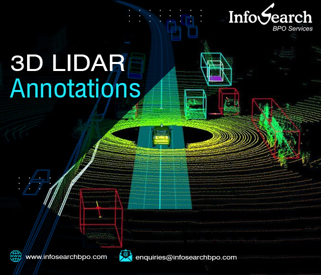
Labeling things within a 3D point cloud is called LiDAR annotation. Here, it is necessary to pick out important things in the environment, including vehicles, pedestrians, cyclists, trees and road signs, so machine learning models can notice and make sense of them.
Unlike common image annotation which often works in 2D, LiDAR annotation takes place in 3D space and usually adds camera images or radar visual data to improve the context.
Kinds of LiDAR Annotation
These are the most typical techniques used to annotate LiDAR data.
Cards drawn around each car or person in the 3D scene. By estimating where, how and how large or small they are, these boxes train models to spot and identify objects.
Every point in the cloud carries the label for its object type such as road, building or tree. As a result, we can understand the entire environment, not only detect objects.
- Instance Segmentation
An improved kind of semantic segmentation that labels each object differently. People use this to recognize a class like cars when many are present at once.
Lanes, curbs or power lines can be annotated using polylines and objects are more exactly defined using cuboids than with bounding boxes.
- Sensor Fusion Note
In many cases, LiDAR data is merged with RGB images or radar. By linking the same types of labels across all the sensors, annotators make sure the training set is more accurate and useful.
Why Is It Important to Label Data with LiDAR?
In areas like autonomous driving, knowing depth and the relationships between objects is absolutely necessary. The use of LiDAR annotation is possible for:
- Having the ability to detect objects in 3D helps a vehicle stay safe and avoid trouble.
- Building realistic 3D maps of environments requires scene reconstruction.
- Motion prediction is about determining the movements of objects between frames.
- Because dynamic cities have lots of foot and road traffic, it is important to examine human behavior in detail.
Even though LiDAR annotation is important, it has several problems.
- Coverage of point clouds changes with the distance from the sensor.
- Some objects may be masked in part by other objects.
- It takes longer to do 3D annotation than 2D annotation, mainly because of the third dimension.
- Proper labeling is possible only with trained workers and the right assurance steps.
What Does the Future Hide for LiDAR Annotation
Thanks to new automation tools, LiDAR annotation is improving its efficiency.
- A computer partitions the task, with humans selecting object types and sending back corrections.
- Some deep learning methods such as PointNet, PointRCNN and PV-RCNN, make use of 3D annotated data to boost a model’s accuracy.
- Making synthetic data and simulations: Producing annotated LiDAR point clouds in simulated spaces to boost the information in real-world sets.
Because autonomous systems are moving forward, LiDAR annotation will require better targeting and more direct integration with fast data streams.
Final Thoughts
AI needs LiDAR annotation as it is the key to helping AI understand objects in three-dimensional space. To help a self-driving car avoid pedestrians or allow drones to fly and land correctly, accurate LiDAR annotations are required.
It is very important to learn LiDAR annotation if your AI systems are interacting with the physical world or to partner with experts who have that knowledge.
How to reach Infosearch?
https://www.infosearchbpo.com/contact.php
enquiries@infosearchbpo.com
Contact us through the below form.


Recent Comments