Your personal data shared with us through this form will only be used for the intended purpose. The data will be protected and will not be shared with any third party.
To other BPO centres. We execute all projects in house only.
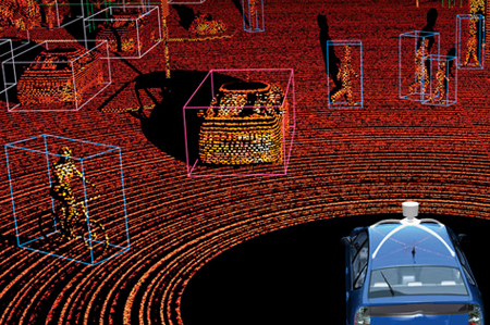
3D LiDAR Annotation
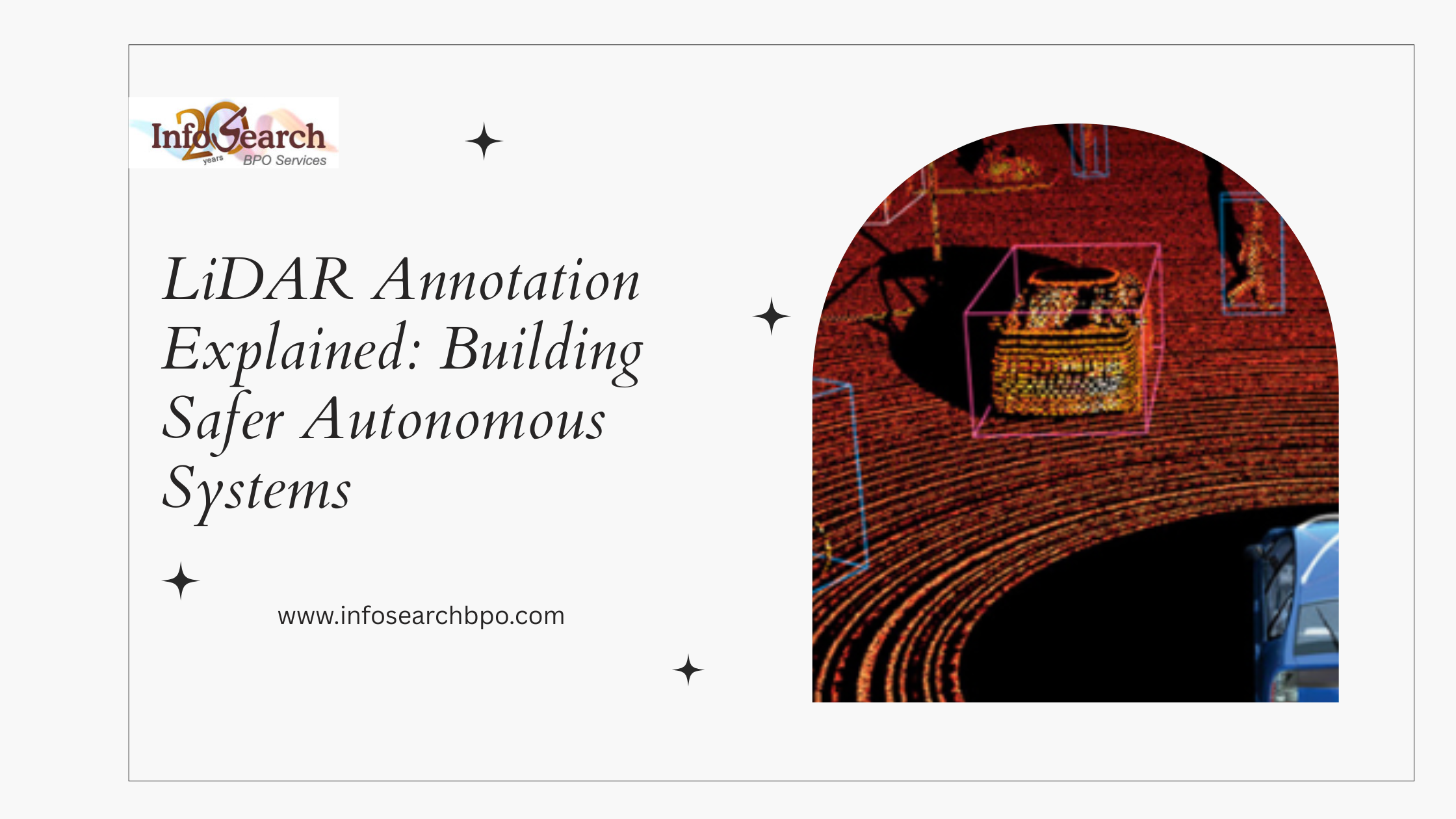
3D LiDAR annotation (Light Detection and Ranging) enables you to label, visualize and associate objects across 3D point clouds for all types of LiDARs. Autonomous vehicles, drones and agriculture all use this technique.
LiDAR annotation is one of the most important services required for Autonomous Vehicles. Fully automated vehicles utilize LiDAR extensively as they require large amounts of datasets to label. Data Labeling is an important aspect of deep learning, because it involves the labeling of a large volume of data. We offer you 3D LiDAR annotation support service in three different formats, in addition to the expertise that we have in line annotation, image annotation and video annotation.
We provide 3D LiDAR and point cloud annotations to Global companies including countries like Germany, Japan, USA, and Netherlands.
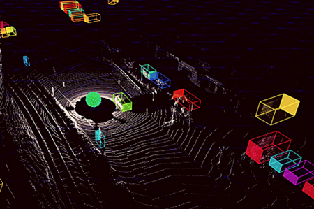
3D Point Cloud Annotation
LiDAR sensors understand 3D point clouds by marking each point on an object, enabling the identification of precise objects in both outdoor and indoor environments. A 1cm object can be annotated with 3D box annotations by defining each point on the object.
3D LiDar Annotation For Vehicles
3D Point Cloud Annotation For LiDAR
Applications of 3D Point Cloud & LiDar Annotation
3D LiDAR Semantic Segmentation
With the help of point cloud semantic segmentation, any object can be analyzed for its additional attributes, which can assist the learning processes. A 3D point cloud map can be used to distinguish different types of lanes efficiently, which is highly useful for self-driving cars. The differentiation will enable them to provide the roads with highly precise 3D modelling, allowing them to provide safer and more accurate driving directions.
3D LiDAR To Annotate 3D Boxes
At Infosearch, we use the tool of 3D point cloud labeling, such as the roll, yaw, pitch, and heading angles, to detect the objects and tracks efficiently and precisely. Using this tool, you can label a variety of objects much more effectively, thus upgrading the level of your models.
Lane Detection Using 3D LiDAR
A road lane can be detected and the objects tracked within the frame, enabling the labeling of moving objects across multiple frames. Interactive annotation using semi-automated processes can be used to label any 3D object in just one click. To make the process of labeling much quicker, our team will utilize advanced annotation tools including linear interpolation and various other advanced tools.
Outsource 3D LiDAR Annotations to Infosearch
Using machine learning, annotation service support manages the most complex workflows associated with selecting data, annotation, and modeling. We deliver quality point cloud annotation, 2D mapping, 3D object tagging, and semantic segmentation of point clouds with our experienced annotators. In addition, annotation support helps improve the quality and security of the model provided by the whole machine learning process.
3D Point Cloud Annotation for LiDAR
FAQs
LiDAR annotation has found a variety of applications in products that demand precise knowledge of the environment in 3D, such as:
Self-driving cars and driver assist.
Industrial automation and robotics.
Traffic monitoring and smart city.
Urban planning and geospatial mapping.
Agriculture and land analysis.
Monitoring of infrastructure and construction.
Surveillance and security systems.
The applications are based on the use of accurate 3D spatial information on object detection, navigation, and decision-making.
Our LiDAR data labelling methods are sophisticated to provide a 3D object detection and scene understanding, including:
Cuboid 3D annotation of spatial positioning.
Point cloud classification and segmentation.
Frame tracking Object tracking Objects may be tracked across multiple frames.
Sampling the environment: Semantic segmentation of 3D environments.
Object differentiation by instance labelling.
Annotation based on sensor fusion.
These methods assist AI models in processing complicated environments and enhancing the forecasts.
The 3D LiDAR annotations are commonly of the following types:
3D bounding box / cuboid annotation -describing the dimensions and location of objects.
Semantic segmentation - assigning one point to each category of classes.
Instance segmentation - separation of single objects of a class.
Point-level classification>- labeling particular data points.
Object and trajectory tracking - tracking the movement of objects with time.
Both approaches are used to support the various AI training needs and applications.
The LiDAR annotation process usually consists of:
LiDAR sensors were used to collect data.
Point cloud cleaning and noise cancellation.
Sensor calibration and data alignment.
Specialty tools annotation.
Quality checking and monitoring.
Delivery and formatting of data sets.
This organized procedure provides proper labeling of space and the uniformity of training data of machine learning models.
LiDAR annotation offers precise spatial data in the form of depth, distance and the orientation of the objects in 3D and is not possible to achieve in 2D image annotation. This allows autonomous systems to know more about the surrounding environment, recognize the barriers and calculate the position of objects in real time.
Under low-light conditions, or other adverse environmental conditions, LiDAR data also performs fairly well and therefore is quite useful in safety-critical applications such as autonomous driving.
We solve the issue of sparsity in LiDAR data with the aid of sophisticated preprocess procedures, interpolation, and analysis of the surrounding points. Our trained experts are able to label objects with high precision when there is low point density as they apply structured guidelines to annotate.
We also use quality validation and sensor fusion methods to enhance completeness and consistency of data in long range.
Sensor fusion annotation: This is the data-set of several sensors (LiDAR, cameras, radar, GPS) that has been combined to produce the complete and precise view of the surrounding environment.
Sensor fusion enhances the accuracy of object detection, depth perception, and scene understanding of AI models, particularly the autonomous systems, by matching and labeling the data obtained using various sensors.
3D point cloud annotation services are applicable in a broad industry, which includes:
Self-driving cars and mobility.
Robotics and automation
Construction and engineering.
Intelligent infrastructure and traffic control.
Geo services: Geospatial and mapping services.
Agriculture and environmental surveillance.
Military and homeland security.
These industries are dependent on high accuracy 3D data analysis, planning, intelligent automation.
Before you leave our site, please give your email id for us to contact you.
Your personal data shared with us through this form will only be used for the intended purpose. The data will be protected and will not be shared with any third party.
InfosearchBPO
Success!
Thank you for your enquiry. We will contact you in 24hours.