Your personal data shared with us through this form will only be used for the intended purpose. The data will be protected and will not be shared with any third party.
To other BPO centres. We execute all projects in house only.
Geospatial Data Annotation
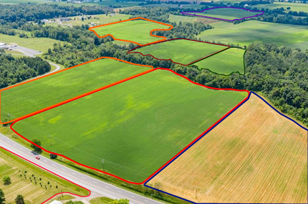
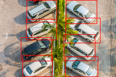
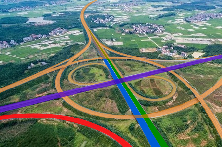
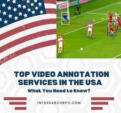
Our geospatial annotation services enhance the status of data visualization by using map imagery. Annotations are included in the map to assist firms in obtaining extensive aids and increased scalability. Using remote sensing technologies, our team constructs geographic models. Our team uses remote sensing technologies to create geographic models. Drone imagery, satellite imaging, and aerial imagery are examples of data that may be collected and used to train computer vision models using machine learning technology. We provide Bounding Box and Semantic Segmentation services to this industry. We use bounding boxes for buildings, automobiles, parking lots etc. and semantic segmentation for land covers, water bodies, agricultural areas.
Contour Annotation
Contour annotation is one of the methods of image annotation activities in which boundaries of the objects, or regions of interest, are delimited using edges within the images. The technology is applied in any task involving fine geometric data including object identification, image partitioning, and computer vision. Contour annotation gives highly accurate labels superb boundary descriptions of objects, which is perfect for training artificial intelligence models such as medical imaging, autonomous car, and facial recognition systems.
Drone Imagery Annotation For Satellite Image recognition
The data acquired by Satellite, GIS, GPS, Drone etc. are annotated to create geographic models. The process involves annotating roads, water bodies, forests, agricultural land, deserts etc. as part of machine learning exercise. Some of our clients use geospatial data to annotate ship building yard, harbor, Solar panels etc.
Drone-imagery and aerial view annotations, semantic segmentation, and bounding box annotations all require geospatial annotation services. We are a leading provider of comprehensive data annotation services that enhance the performance of your converting algorithms.
Contour Annotation
Drone Imagery Annotation
Geospatial Annotation
Geospatial Annotation For AI & Machine Learning
Geospatial data incorporates a major piece of existing data that is extremely important for business decision-making and planning. For some specific business fields, such as agriculture and emergency management, it is absolutely important. However, using geospatial data directly would be complicated and time-consuming. We give extra files stored with such new information for you to analyse the data that are obtained from geospatial annotation services.
Data is collected from a variety of sources, including location GPS, sensors, satellite imagery, mobile devices, and social media using our Geospatial annotation service. Cartograms, maps, statistics, and graphs that show drifts and historical evolutions are good candidates for such visualisations. It's one of the best tools for making predictions. As the data may be applied to literally anything on the planet, we can say the geospatial annotation is extremely adaptable.
Outsource Geospatial Annotation Services to Infosearch
Our annotation services are used to determine user-generated information such as comments, remarks, and results, as well as other information gathered from the real world. Through accurate data collection and annotation, we provide exclusive geospatial annotation services that are precisely modelled, secured, and visualised. As most of the existing annotation models do not fully align with geographical contexts and hence fail to reveal the needed spatial links associated with annotations, our annotation specialists help you in customizing the model to your requirement.
Popular Searches:
geospatial services, geospatial machine learning projects, geospatial annotation for ai, geospatial annotation for machine learning, outsource geospatial annotation services
Geospatial Annotation Services At Infosearch
FAQs
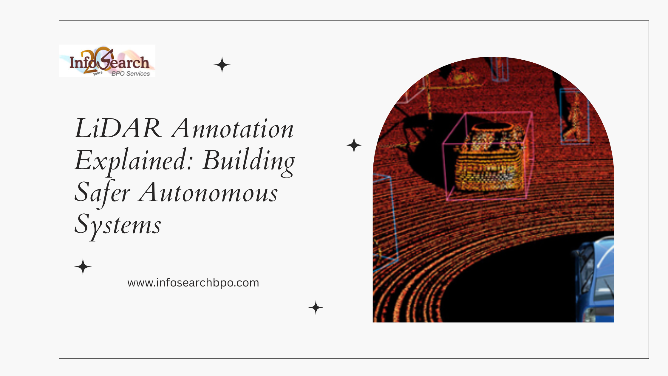
There are several methods of annotating spatial data with great precision, referred to as geospatial annotation, which are bounding box annotation, polygon annotation, polyline annotation, semantic segmentation, contour annotation, point labeling, and 3D point cloud annotation. It is also used to extract features, classify objects, map the terrain, and tag attributes with satellite images, aerial images, GIS data, and LiDAR data to determine geographic features such as a road, building, vegetation and land boundaries.
The high-resolution satellite images, aerial photographs, images taken by drones, the LiDAR point cloud, digital elevation models (DEM), geographic information system (GIS) datasets, and topographic maps are usually used as contour annotations. These sources contribute to proper representation of the terrain elevation, surface and landscape boundaries to map and analyze the surface.
The geospatial data labeling is very popular in urban planning, agriculture monitoring, disaster management, environmental monitoring, land use classification, infrastructure development, navigation systems, autonomous driving, and smart city programs. It assists organizations to derive meaningful insights on geographic data to aid in planning, decision-making and predictive analytics.
Normal image labelling pays attention to objects in pictures without any inferences whereas geospatial labelling includes geographic positions, spatial connections, height data, and geographical locations. Geospatial annotation ensures that the features that have been labeled are put at the right position on the surface of the Earth and thus it is appropriate in mapping, navigation and analyzing location.
Human-in-the-Loop (HITL) is highly accurate, as it is based on automated AI predictions and verified by experts. Human annotators are used to validate the complex geographic features, eliminate the ambiguity, and dealing with the edge cases and model error correction. The method enhances the reliability of the models, minimizes bias, and guarantees consistency in outcomes when dealing with important uses of the models, e.g. mapping, infrastructure planning and environmental analysis.
Geospatial annotation is also used in industries such as mapping and GIS companies, urban planning and construction companies, agricultural and forestry organizations, environmental agencies, transport and logistics companies, autonomous vehicle developers, telecommunications companies, energy and utilities companies, defense agencies, and smart city projects.
The geospatial annotations may be provided in geospatial standards like GeoJSON, Shapefile (SHP), KML/ KMZ, TIFF/ GeoTIFF, JSON, XML and proprietary GIS-compatible formats. We are also compatible with metadata standards such as coordinate reference systems (CRS), projection data, attribute tagging, and custom schema demands to ensure a smooth integration with machine learning and GIS processes.
Scalable workflows, cloud-based processing infrastructure, automated pre-processing pipelines, and distributed annotation teams are used to deal with large-scale datasets. Quality control measures, version management and batch processing ensure the quality of annotations and effective management of the high-volume mapping projects or city-scale mapping projects.
Yes. We have a very stringent process of data security and confidentiality which includes secure data transfer processes, controlled environment of access and non-disclosure terms and adherence to industry data protection guidelines. Specialized security protocols are in place so that the confidential data on geographic and infrastructure is completely safeguarded throughout the annotation process.
Before you leave our site, please give your email id for us to contact you.
Your personal data shared with us through this form will only be used for the intended purpose. The data will be protected and will not be shared with any third party.
InfosearchBPO
Success!
Thank you for your enquiry. We will contact you in 24hours.